See photos here.

This is Alaska - nearly half of it is above the Arctic Circle where for some days during Summer, the sun never sets. It touches the horizon and rises back up (not much though.) At Arctic Circle, less than 100 miles north of Fairbanks, that happens exactly ONE day each year on Summer Solstice -around June 21.
At Barrow (also known as Utqiaġvik), the state’s northernmost community 503 miles north of Fairbanks and 300 miles above the Arctic Circle, sun does not set for more than two and a half months—from May 10 until August 2. By contrast, from November 18 to January 24, the sun never rises above the horizon.
How then do the locals decide when to sleep? Using a thermometer. They sleep when the temperature falls, and get up when it is warmer, relatively speaking. On June 3, the day we were in Barrow. it was completely covered with low clouds - we saw sun only before we landed and after we left. High temperature 32 degrees; low 28. The Arctic Ocean in front of us was frozen for about a mile from the shore, though the ice was thinning in places and it was dangerous to drive snowmobiles on them. We were still far away from the earth's north pole (1300 miles as the sign below indicates.)
 |
| Do you know where you are? Far away from everywhere. |
Having driven extensively in the "Lower 48s" (so called because Alaska became the 49th state in 1959, and all other 48 states are at lower latitude than any part of Alaska including the Aleutian Islands. Hawaii became the 50th state later that year, and they call the other states "Mainland."), driving to Alaska seemed like a natural thing to do. After all, how bad can it be if it's all highway driving, or open road with very little traffic - right? Well, one closer look at the map and you quickly realize how far it actually is. It's nearly 3000 miles from Northern California to Fairbanks - the north-most point on Alaskan Highways. (Ice road truckers go beyond that, of course.) That round-trip itself would take 10 days or more of driving in good weather.
One year earlier, I was in Seattle, WA for a convention where they had offered an add-on one week cruise to Alaska - Inside Passage. I had not thought about Alaska before then, but when I heard stories from other attendees about how wonderful that cruise was, I wished I had gone as well.
Researching cruises to Alaska, I found a 10 day round trip cruise from San Francisco to Juneau - not even to the main part of Alaska state. From Seattle or Vancouver, a 7 day cruise would take you to Anchorage - 14 days round trip, and that too doesn't really give any time to see the State itself. For that, you need additional week or longer depending on your interests. Drop the cruise idea! Even Google Maps tells you that a 6 hour flight would get you directly to Anchorage/Fairbanks. Duh!
Alaska's short tourist season begins on June 1. From then on, all prices double - airfares, hotels, rental cars. I happen to have just enough miles on Alaska Airlines for free round trips to Anchorage via Seattle - only 10,000 points each way, if the trip began before June 1.
We planned a 7-day whirlwind trip - 7000 miles of flying, 1500 miles of rental car driving - to experience every possible major thing there is in Alaska - the fjords; blue ice/glaciers; wild life (whales, sea lions, sheep, moose, rabbits, fox, bears and many birds); frozen mountains including the tallest Denali; 800 mile Alaska Pipeline from North Shore (Prudhoe Bay/Deadhorse) via Fairbanks to the south end Valdez; Barrow - the north-most point of U.S.; North Pole AK - where year round Santa sends you postcards stamped "North Pole" - although the actual north pole is about 1700 miles away. Did I mention Salmon and Moose-burger?
 |
| Oh, and free snow shoveling experience. |
Trip plan evolved over time. As we read reviews and researched, What's in and What's out changed. For example,
- Cruise tour brochures to Alaska (like Princess Cruises) advertise how wonderful it is to take the glass domed train from Anchorage to Denali. The trip takes eight hours and after a while, the scenery doesn't change much at all. Denali (Mount McKinley) itself is so far away from the train tracks/road that you wonder what the purpose of the train ride was, and whether the time commitment was worth it. Road runs nearly parallel to train tracks, and when driving, you can stop anytime you want - and take pictures.
- Therefore, rental car ended up being the preferred alternative. Using unlimited mileage, we decided to make the full loop - Highways 1-2-3-4. Hwy 1 between Seward and Wasilla (and beyond on the return trip), Hwy 3 from Wasilla to Denali to Fairbanks, then Hwy 2 down to Delta Junction, then follow Alaska Pipeline to Valdez on Hwy 4, and then back to Anchorage. Our route
- Having gone so close to the Arctic Circle, we couldn't miss the opportunity of checking off "Cross the Circle" from our bucket list. The road from Fairbanks is about 84 miles of unpaved Dalton Highway, used primarily by ice road truckers. Rental cars agencies prohibit you from driving on it. For $200 pp,, tour buses will take you to a spot called the Arctic Circle - 13 hours round trip. Even then, unless it was exactly June 21, there wouldn't be a 24 hour day - not to mention that you wouldn't stay there until midnight to witness it.
- That's when the idea of going to Barrow came up. Going to Prudhoe Bay, where Alaska Pipeline originates, was also tempting. There are however restrictions on going to the oilfields at Prudhoe Bay, and otherwise, there is nothing else to do. Luckily, Alaska Airlines had an early morning flight to Barrow, with a stop at Prudhoe Bay, so we could at least see the area from the plane. Round trip tickets were rather expensive - $300 pp., but the experience priceless!
Day-by-Day:
- In Anchorage, Sunrise was around 4:30 am and Sunset 11:30 PM. Daylight was definitely not an issue - we had plenty of time to do things today. We rented a car from Enterprise (through HotWire) for $146 for one week, unlimited mileage and drove down to Seward, 127 miles south - first on Hwy 1 and then Hwy 9.
- The weather was nice - clear, a bit on the cold side, but not bad at all. Though most populated city in Alaska, Anchorage situated on the northwest tip of the Turnagain Arm, is relatively small in size. Within minutes, you are out of Anchorage and in Chugach State Park. Hwy 1 takes you around the Turnagain Arm and through the valleys towards Homer. For Seward, you turn left on Hwy 9 about 90 miles later.
- Right away, you notice surrounding snow sprinkled dark granite mountains - they looked particularly ominous as it got darker. With hardly any other cars on the road, we zoomed down the one lane road. Around one bend, a bear cub suddenly appeared out of the trees on the right and in front of my car. I swerved to avoid it - that worked only because, at the last moment, the cub turned right back and disappeared. Phew, that would have been some accident. Did I purchase CDW (Collision Damage Waiver)?
- Just before Seward, a short detour took us to our first glacier - Exit Glacier. It was nearly 10 PM Alaska time. The glacial ice looks blue-ish because all oxygen has been squeezed out of it by layers and layers of snow/ice on top over the centuries. That is also why it melts slower (though glaciers are melting, for sure.) The glacier was almost close enough to touch - just beyond the reach.
 |
| Blue Ice of Exit Glacier |
We had a long 350 mile drive to Denali afterwards, and our chance to drive at midnight with headlights off! For the night, I had a reservation for a shoulder season rate of $110.00 at Cedars Lodge in Denali National Park and Preserve, just before the park entrance I had notified them about our late arrival, and knew how to get the room keys.
- The first 25 miles of the cruise is just getting out to the entrance of Resurrection Bay. Soon afterwards, we were visited by a pod of Orcas (Killer Whales) Although Shamu, the killer whale in Sea World, looks huge next to the tiny dolphins in their pool; here in open ocean, the orcas looked tiny. Like on cue, they approached our boat, swam around first on this side and then the other, and then swam away. No jumps or flips or flukes, though.
 |
| A pod of killer whales swam around our boat |
- The prime attraction of this cruise was to see the Holgate Arm of Aialik Glacier, a tidewater glacier gently sliding in to the ocean. As the glacier slides down, and ocean water continues to melt its bottom portion, chunks of ice cracks and slides off in to the ocean with thunderous sounds. This calving process is ongoing, but its timing is not. As we approached the glacier, we saw icebergs floating in the water around us. The captain took the boat close enough, but safe distance away from, the glacier. As we were watching, we were able to capture "before and after" pictures of calving for our scrapbook.
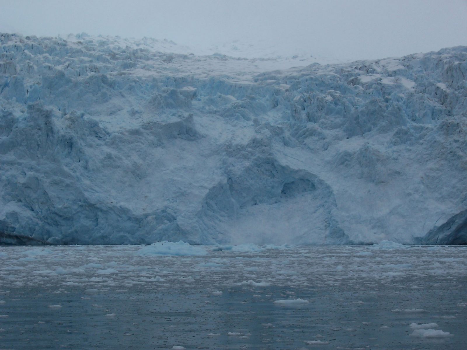 |
| Up close to a tidewater glacier slipping in to ocean |
The tour company had delivered on its promise, and brought us back to Seward right on time. Our car was parked nearby, so we were soon back on Hwy 9 driving to Anchorage/Wasilla on Hwy 1, and then up north on Hwy 3 to Denali. There were plenty of "Moose Xing" signs, but of course, NO moose. I wondered if anyone told the moose about these signs ;-)
- In the lower 48s, we know that days are longer during summer - sunsets as late as 10:30 PM. But it does get dark after that. Days would be longer as you travel further north, but you still can't imagine light at midnight. How is that possible? Well, today was our day to find out. Summer Solstice still being 3 weeks away, it wouldn't be the longest day, but close enough. Will the twilight be sufficient for us to see the road without headlights. The answer is definitely YES. We have the proof below. There were no other cars going in either direction that we could see (May be they were also driving without their headlights!) Joking aside, here is a picture of mountains taken at that hour. There was sufficient light.
- In the lower 48s, we know that days are longer during summer - sunsets as late as 10:30 PM. But it does get dark after that. Days would be longer as you travel further north, but you still can't imagine light at midnight. How is that possible? Well, today was our day to find out. Summer Solstice still being 3 weeks away, it wouldn't be the longest day, but close enough. Will the twilight be sufficient for us to see the road without headlights. The answer is definitely YES. We have the proof below. There were no other cars going in either direction that we could see (May be they were also driving without their headlights!) Joking aside, here is a picture of mountains taken at that hour. There was sufficient light.
 |
| Dark rocky mountains in "midnight sun" |
- We reached Cedars Lodge around 1 AM., found the room key, and got some sleep. This lodge is just outside the park boundary, on the south bank of Denali River - about 8 miles south of the entrance to Denali National Park, our destination for tomorrow. Tomorrow should be an easy day.
 |
| Denali |
- I had not discovered the mountain hiker in me yet, so climbing Mount Denali over 20,000 feet elevation wasn't even a consideration. This climb is technical, includes a 60 mile flight from the Visitor Center to 6,000 ft up on the mountain, and then nearly 2-3 weeks of climbing over glaciers to the summit. I was happy just watching Denali from a distance. Little did I know at the time, that in less than one year, I'd climb 18,000 ft. to view Mount Everest up close - less than 5 miles away.
- Today, the weather was clear and pleasant. Some clouds were floating by the peaks of Denali. We drove 15 miles up to Savage River. Along the way, if you see a car stopped in either direction, that's an indication that some wild life is nearby. We saw a bear with two cubs across the river foraging. Wish they were on our side of the river.
- At Savage River, the road is closed for private vehicles. We parked and followed others on a hike on one bank of the river for some distance, crossed over and returned to the car. Up on the hill sides, we saw many sheep, a couple of caribou. To see red fox, snowshoe hare and moose, we had to get back on Hwy 3. So much for abundant wildlife! To see herds of moose roaming around, we were told, you need to visit the north slopes of Alaska. We will be flying over it in a couple of days. Let's see if we get lucky.
- Just outside the park, we saw signs for river rafting (another one from the bucket list.) The description read: "This river trip begins at the entrance to Denali National Park and journeys 11 river miles to Healy, Alaska. During this 2 Hour whitewater adventure expect to encounter over 10 major Class III to IV rapids in the Nenana River Canyon! The Denali National Park frontier will be the setting on your river left shore with Mt. Healy rising over 3,000 feet to the summit. Exciting wave-trains and powerful hydraulics will create rapids like "Razorback," "Iceworm," "Cable Car," "Royal Flush," and “Coffee Grinder!” No experience is required." Sounded perfect, so we did.
- Nenana river runs glacier water north towards Fairbanks. The canyon creates the exciting whitewater rafting experience. Although the water was cold, we were comfortable in our Gore-Tex Drysuit, neoprene booties (and life jackets.) For our 3 PM run, they had enough people to fill up 3 rafts - most with prior reservations, some like us impromptu. After loading all three rafts, we left together - following the raft ahead of us at a safe distance. By watching them, we knew what adventure lay ahead of us. We had paddles, but whether we paddled or not, the guides were managing just fine navigating those rapids. It was a lot of fun.
- Towards the end, we reached a quiet stretch of the river. Our guide explained what "man overboard" concept was, and asked if any of us wanted to go overboard. At first, I didn't think he really meant it. No one else on our raft volunteered. After a few moments, I heard people from the raft behind us shouting "man overboard." and saw someone in the water. So I asked our guide, who said "Sure. You should have asked earlier!" I would have had more time to float that way.
- He oriented the raft such that I was upstream to the raft - easier to stop me from floating away. We were all sitting on the side tube of the raft. As they show in the movies, I let myself fall backwards in the water head first, and then somersaulted back up. Thankfully, water was deep enough at that spot and I didn't hit my head on anything. Before our guide could stop me, I was already in the water. I floated by our raft for a few minutes before I was asked to get back - others pulled me in. This was my version of Polar Bear Club - it was glacier water - except for my head and hands, the rest was dry. Good enough for my bucket list! We got off our rafts near a bridge to our waiting vans which brought us back to our cars.
- Our stop tonight was close by - only 13 miles from the park entrance, in Healy. We had no trouble finding this unique dome home at 137 Healy Spur Rd.
- This was our first experience with a B&B, and we weren't sure how it would turn out. It was much cheaper than hotels - even cheaper than shoulder season hotel prices, and included much more. We were pleasantly surprised. Here was the description:
 |
| Snow Shoes at the doorway remind you to take off your shoes before entering |
- Mr. Miller greeted us at the door to this geodesic home, welcomed us in the foyer where there was a long bench and snow shoes hanging on the wall. He explained that in Alaska, it is customary to remove shoes at the door. I was well too familiar with that custom. (And snowshoes now hang by my front door.)
- With our shoes off, we went inside the house. Another couple had already arrived and they were all chatting at the dinner table. Smell of delicious chocolate chip cookies spread through out the house. Mr. Miller showed us to our room with attached bath, and asked us to join others for cookies and discussion. His large property - no fencing - was open to animals for grazing. We saw a caribou in one corner. I mentioned that with all the "Moose Xing" signs, we are yet to see a single moose. One of the other guests had seen one just a few minutes earlier, near the highway. So we rushed back and drove around - no moose! (The only one we saw was next morning back on Hwy 3 by the roadside. So much for that!)- The host, Mr. Miller, was very helpful, and knowledgeable about the area. When he found out that we needed a place to stay in Fairbanks, he offered his house there for two nights for only $79/day - he had extra house keys with him, and when done, we were to leave keys at the Fairbanks house. Perfect.
- Monday, June 2, 2008 - The made-to-order breakfast was sumptuous. We returned to Denali Park for Dog Sledding demonstration. Those wild dogs / huskies are much larger - more like wolves - and much stronger. They have been trained to pull the sleds long distances and fast, and are used to patrolling the park during winter. With no snow around at this time, the dog sledding experience was on a dirt path, but it did not seem to make any difference to the dogs.
- We then drove 120 miles north to Fairbanks. Fairbanks is a popular destination for Northern Lights or Aurora Borealis, during winter, and Midnight Sun Festival around June 21, Summer Solstice day. And as noted earlier, for crossing the Arctic Circle.
Dog Mushing at Denali National Park
- Many, many years ago, when computers were new and just beginning to be used at work all day long, CRT monitors needed screen savers to prevent burn-in. After the initial blank screen, followed by Flying Toasters, Swimming Fish, Rolex Watch, King Tut, I had Aurora Borealis as one. That was my closest experience with Northern Lights, and this trip wasn't going to change that.
- In Fairbanks, we planned two main To Dos - gold panning, and seeing Alaska Pipeline for the first time - at 1671 Steese Hwy a few miles north of Fairbanks on Hwy 2. Tomorrow, whether we actually see it or not, we will fly over it 400 miles north to its starting point at Prudhoe Bay/Deadhorse. Then the day after, we will drive along it down south to the other end, Valdez. Part of the pipeline is underground on Permafrost.
- For gold panning, we were recommended El Dorado Gold Mine. This two hour tour began on a replica of an old railroad, and then over to gold panning area.
- First, we saw a demonstration of how the dirt brought up from the mine is crushed and run through sieves under running water so only the most concentrated dirt is selected for panning. Next, we were given plastic bags full of dirt ready for us to take to the panning stations and begin panning.
- They promise gold in every pan. Sure enough, we found a flake or two, which they weighed, valued at $5 - and gave us to bring home. If you have never panned for gold, it is worth doing it once. Just imagine how tough life would have been back during the gold rush days when everyone was after the same thing, and very few people found enough gold to get rich.
- Before returning to our rental house, we stopped by a Walmart (Really!) I don't like to shop there, and vowed many years earlier never to go there - because it is too crowded and disorganized. Any case, this Walmart was different. It was a huge, sprawling Super Center, with everything imaginable, all in one place. We purchased an Alaska T-shirt (below) and a souvenir glass bottle with pure gold flakes. Had we known earlier, we would have also purchased smoked salmon there - Walmart and Costco sell excellent local salmon varieties just like boutique shops in Anchorage do. - Tuesday, June 3, 2008 - Very excited about today, though not sure about how good/bad it was going to be.
- I like to visit places or do things that are the -est (like tallest, shortest, fastest, slowest, highest, lowest, farthest and so on.) We had already been to the South-most point in the U.S. - the south tip of Big Island of Hawaii. Barrow will be the North-most. Also, because of its geography, Alaska is the western-most state, as well as eastern-most, with Aleutian Islands crossing the date line, We had already seen Denali, the tallest mountain in North America, and earlier, the lowest point, Badwater in Death Valley, CA.
I had never seen a frozen ocean before today (Not even a lake. Lake Michigan freezes further up north, but not in Chicago.)
- One option was to join a guided tour ($150 pp for 5 hours) - reviews indicated that most places were within walking distance from the airport.
- Our 7:36 am flight from Fairbanks had a short stop at Prudhoe Bay and reached Barrow at 10:29 am. Our return flight was at 8 PM - that gave us 9 1/2 hours to plan for. We decided to create our own tour once we got there.
- We landed at Wiley Post-Will Rogers Memorial Airport (BRW) on time. Named after aviation pioneer Wiley Post and humorist Will Rogers, who both died in a plane crash 16 miles south of Barrow in August 1935. While Barrow has 27 miles of roads, none of them lead to the actual crash site, so a memorial inside the city limits was dedicated on August 15, 1982. See Wiley Post and Will Rogers Crash Memorial
- BRW airport doesn't even have a control tower. A strip of land between the ocean on the west and a lagoon on the east serves as the runway. A warehouse like building is the terminal. It is open only when the handful of flights are arriving or departing. If the weather wasn't good, staying put at the airport until our evening flight wasn't an option.
- Fairbanks was comfortable 60s today, whereas Barrow was going to be at freezing or lower (and this was Summer for the locals.) The cold hit us the moment we walked out of the terminal on the Ahkovak Street. Those who had signed up with the tour group got picked up in nice, warm buses, and they departed. A few were going to stay overnight at the hotel across the street. I thought we made a huge mistake by NOT going with the tour group. (Even then we would have 4 1/2 hours on our own.) In the end, it all worked out.
- First thing we realized was that we forgot our camera. Solution: let's just buy a single use camera for say $5 - problem solved. Well, there was no concession stand at the airport itself. A convenience store (another warehouse like building) was a couple of blocks to the west. We found the place - they had only one kind of single use camera - price $16 - opportunity cost, I suppose. We had no choice - had to have pictures of this day. We purchased it and started walking back east to town. (Should have had Arctic Pizza next door, while we were at it! But it was too early.)
- Post office and schools were near the airport on the west side of Barrow "downtown", and the rest of the town is on the east beyond the lagoons "Browerville." At the elementary school, children were playing on swings and slides as though it was summer (It was, wasn't it?)
- Walking past the lagoon, we reached Stevenson Street. This two lane dirt road runs parallel to the ocean from the airport through the town, and past many lakes and lagoons to Point Barrow/Port Moore - the north tip about 6 miles away. Barrow itself is about a mile across.
- A short strip of sandy beach lay between the Street and the Arctic Ocean, which was still frozen as far as the eye could see. We estimated that to be about a mile. How do you tell? The reflection of light off the water causes a gray aura to appear on the horizon where the ice ends. During winter, you can drive around on snowmobiles (a big time rental business during the season.) anywhere. Now that summer is approaching, the ice sheets were too thin at many places, so you are advised not to drive on the ocean.
- But you could walk on it! There was a boat parked on ice. I walked to it, avoiding water puddles, and had my picture taken (below.) I later found out that the Captain who successfully kills a whale during the previous hunting season gets the honor to "park" his boat on the ocean until the following season, with their flag flying high. Big bragging rights! I also found out that where I was standing for the picture, the ocean is probably 10-15 feet deep. (I would have walked more carefully, had I known. Luckily, the ice was thick enough.)
 |
| Winning boat from last hunting season. Gray aura to the left marks the edge of the frozen ocean. |
- As you notice from the pictures, Barrow is all about hunting whales (and tourists.) Whale bones are everywhere. Even a piece of whale blubber could be found tossed by the side of the road. Only a few whalers are successful in hunting each year. Four men crew in these tiny boats do all the work - kill the whale with guns and harpoons and then tow it back to town. The captain of the boat gets to take half the whale. The rest is distributed to the other 3 whalers and shared with the rest of the town. Cleaning up the whale, and packing all meat in the freezers (an underground room in ice) is a community activity. Watch Art of cutting a whale if you want to know more.
- Up until a century ago, whale oil was used worldwide for oil lamps (and to make soap and margarine.) Later, kerosene, vegetable oils, and then electricity replaced it almost entirely.
- Whale meat is very good for human consumption, and primary food source in places like Barrow where nothing else grows. Today, Barrow homes are comfortably heated with geothermal heat, and lit with electricity generated using oil and gas (fossil fuels) also abundant locally.
- Barrow is in a permafrost zone that is 1300 feet thick.- the ground is permanently frozen here. This flat land jutting out in the Arctic ocean means it has no protection from weather. It can get very very cold in winter. It is also one of the cloudiest places on earth. Oh, but if you like it here, the minimum wage is $18 an hour.
- Barrow also has a military installation - a listening post. Being so close to Russia, and as the Northern Sea Route opens up with shrinking polar ice cap, this is a strategically important location.
- Our next stop: Inupiat Heritage Center - all you want to know about the eskimo (now called Inupiat or Inupiaq) culture. We had a warm place to pass time after we are done with all the activities. The library next door had internet access, and nearby grocery store had a small eating area - for sandwiches, etc.
- At the cultural center, we asked the help desk how we could reach Point Barrow. She called someone up who ran private tours (for $30 pp.) for tourists like us. We were a bit hesitant but decided that it was worth it with minimal risk. When the van showed up, we had company. There were two other tourists, plus a couple of other people - his friends or relatives - as well as driver's 5 year old daughter. We figured that this guy was legit. (One of the guys had a rifle with him, for protection against Polar Bears as we later found out.)
- After we left the library, the driver made some unannounced stops to drop off and pick up his friends, but finally drove towards Point Barrow. At one point, he stopped the van and ordered his partner to let out some air from the tires. It is easier to drive on the water if the tires are not fully inflated, he explained. He could see the concern on our faces. I wasn't sure if he was just yanking our chains, or trying to extract more money, or what. But his daughter was still with us in the car, and we figured he wouldn't do anything stupid. In the end, we stayed quiet, and he dropped the subject. After driving some more distance, he stopped. That's as close to Point Barrow we can get, he told. Then he pulled out a sign made from a whale shoulder bone with Point Barrow inscribed on it - for our Kodak moment. Before we got out of the car, he asked his partner to bring his rifle and be on the look out for polar bears. It is difficult to see polar bears on ice, he told us, and therefore, to remain vigilant. Well, like all other wild life, polar bear remained elusive.
- Other Must Do things were to see the sign Welcome to Barrow, with pictures of whales, of course, and taking a picture under the famous Whale Bone Arch below.Near Point Barrow, north-most point in the U.S. Frozen Arctic Ocean behind.

 |
| Under Bowhead Whale jawbone arch, on the Arctic Ocean. |
 |
| Bowhead Whale jawbone arch. Skin-canoes (without the skin) around. |
- After finishing the tour, we spent some more time in the library before walking back to the airport terminal, which opened at 6 PM for our 8 PM flight. Our plane arrived and departed on time, and we made it back to Fairbanks, with another item checked off our bucket list.
- It was cloudy the entire day at Barrow with low cloud cover in all directions. However, above the low clouds, the sky was clear both when we arrived and when we left Barrow. We were able to see parts of the North Slope and valleys beyond where there were no clouds. However, we didn't see any herds of moose or caribou, or any other wildlife.
- Alaska Airlines offers a circular route from Fairbanks to Prudhoe Bay to Barrow to Anchorage / Fairbanks. This must be a very profitable route for the airline, although I suspect that flying must be treacherous during winter months.
- Wednesday, June 4, 2008 - Another long drive day today - 363 miles to Valdez and then back 107 miles to Copper River Lodge, with stops at North Pole, The Knotty Shop, waterfalls, Worthington Glacier, and drive to Valdez.
- Only a 15-minute drive south of Fairbanks, North Pole features holiday decorations and trimmings all year – even if it’s 80 degrees in July. You can drive down streets like Santa Claus Lane, Kris Kringle Drive and Mistletoe Drive or stay the night at Santaland RV Park. The town comes alive in December with the annual North Pole Christmas In Ice Contest, which attracts ice sculptors from around the world. The Winter Festival draws crowds with activities and fireworks. At the North Pole Post Office (located on South Santa Claus Lane) more than 400,000 pieces of mail arrive annually simply addressed to “Santa Claus, North Pole, Alaska.” Each year, teams of community volunteers work to respond to each letter.
- We were advised to visit the Visitor Center first - on the left side of the highway - at 2550 Mistletoe Drive. This interesting looking building had a small gift shop. We got a lot of good information and a map. Just behind, off Mission Road, there were old fashioned homes on Wyatt Road to drive by. One I remember had flower/vegetable garden on the roof top, like in the picture below. The dirt provides great insulation for the house during winter. We saw a similar building again in Anchorage two days later.
Green Home
 |
| at North Pole |
- A few minutes past North Pole, is The Knotty Shop. Giant animals and creatures made from knotty woods attract your attention. This gift shop had snowshoes of the size I was looking for - about the size of a small squash racket.
- About an hour later, at Delta Junction, Tanana River turns South. Hwy 4 Richardson Highway splits off from Hwy 2 and goes straight South to Valdez. So does the pipeline. Alaska is earthquake country. To ensure that the pipeline survives strong earthquakes, on land, it is supported by flexible supports, or goes underground on permafrost. To cross rivers, it is supported by suspension bridges.
- At one point, we stopped for lunch at a roadside restaurant and had a moose-burger. Tasted like leather - much tougher than steak/regular burger.- While enjoying the scenic beauty of surrounding mountains, sun playing hide and seek behind passing clouds, lush forests, rivers, lakes, streams and driving on nicely paved, empty roads on flat terrain, we didn't realize how quickly we reached Copper River, our destination for tonight.
- It was still pretty early, and of course, plenty of daylight left. So we decided to visit Valdez today and figure out what to do tomorrow. The terrain is hilly the entire way to Valdez. Driving through the valleys, snowy mountains got a lot closer to us. There were waterfalls on either side. 75 miles south of Copper River was Worthington Glacier. It was around 7 PM. As usual, there was no one else around. All this beauty and no one to enjoy it - except us. This glacier is large and spread out - melting at some locations with streams/waterfalls flowing in to a frozen lake below. There were places where you could walk close to the ice, but at the visitor center/vista point, large accumulated snow made it impossible to walk around. The visitor center was closed with a sign outside "Free snow shoveling experience" and a shovel below. Enjoy all you want!
- Another 30 miles south is the town of Valdez - made famous because of Exxon Valdez incident several years ago. This sleepy town was still quiet. Luckily some restaurants were open. We had a nice Salmon dinner.
- Drove back 107 miles to Copper River Princess Wilderness Lodge for the night. Princess runs a very lucrative business to Alaska during the short Summer tourist season. Most people visiting Anchorage / Whittier by cruise ships add-on land tours for 7-10 days. To accommodate them, Princess has built lodges at strategic locations - Denali, Kenai, Fairbanks, Copper River. Their primary and profitable business is directly connected with Cruise Ship arrival and departure schedules. For this season, the first cruise ships had not yet arrived, and therefore, rooms were still available only for $99 per night. (During the season, in various Princes Lodges, rates vary from $199 to $349 per night.)
- Copper River Princess Wilderness Lodge is situated on 200 acres at the junction of the Klutina and Copper Rivers. It features 85 rooms and suites with excellent mountain and valley views. The focal point of the Lodge is the Wrangell Room with a staircase to the mezzanine level where you can relax and enjoy the majestic scenery provided by a two-story wall of windows. Wrangell-St. Elias is one of the most spectacular destinations in Alaska and the largest national park in the United States.
 |
| The Knotty Shop |
 |
| Cable suspension bridge for this 48" diameter, 800 miles long pipeline. |
 |
| There was so little traffic that we could stop the car on the highway to take this picture. |
- At one point, we stopped for lunch at a roadside restaurant and had a moose-burger. Tasted like leather - much tougher than steak/regular burger.- While enjoying the scenic beauty of surrounding mountains, sun playing hide and seek behind passing clouds, lush forests, rivers, lakes, streams and driving on nicely paved, empty roads on flat terrain, we didn't realize how quickly we reached Copper River, our destination for tonight.
- It was still pretty early, and of course, plenty of daylight left. So we decided to visit Valdez today and figure out what to do tomorrow. The terrain is hilly the entire way to Valdez. Driving through the valleys, snowy mountains got a lot closer to us. There were waterfalls on either side. 75 miles south of Copper River was Worthington Glacier. It was around 7 PM. As usual, there was no one else around. All this beauty and no one to enjoy it - except us. This glacier is large and spread out - melting at some locations with streams/waterfalls flowing in to a frozen lake below. There were places where you could walk close to the ice, but at the visitor center/vista point, large accumulated snow made it impossible to walk around. The visitor center was closed with a sign outside "Free snow shoveling experience" and a shovel below. Enjoy all you want!
- Another 30 miles south is the town of Valdez - made famous because of Exxon Valdez incident several years ago. This sleepy town was still quiet. Luckily some restaurants were open. We had a nice Salmon dinner.
- Drove back 107 miles to Copper River Princess Wilderness Lodge for the night. Princess runs a very lucrative business to Alaska during the short Summer tourist season. Most people visiting Anchorage / Whittier by cruise ships add-on land tours for 7-10 days. To accommodate them, Princess has built lodges at strategic locations - Denali, Kenai, Fairbanks, Copper River. Their primary and profitable business is directly connected with Cruise Ship arrival and departure schedules. For this season, the first cruise ships had not yet arrived, and therefore, rooms were still available only for $99 per night. (During the season, in various Princes Lodges, rates vary from $199 to $349 per night.)
- Copper River Princess Wilderness Lodge is situated on 200 acres at the junction of the Klutina and Copper Rivers. It features 85 rooms and suites with excellent mountain and valley views. The focal point of the Lodge is the Wrangell Room with a staircase to the mezzanine level where you can relax and enjoy the majestic scenery provided by a two-story wall of windows. Wrangell-St. Elias is one of the most spectacular destinations in Alaska and the largest national park in the United States.
- Thursday, June 5, 2008 - I went for a walk in the morning, hiking down hill through the forest to the river below. On the way, someone returning from his walk told me about bear sighting and asked me to be alert. I didn't see any other person for the rest of the hike - nor the bear.
- Having finished everything we wanted to, we only had to drive 200 mile back to Anchorage. If we were willing to drive another 150 miles round trip beyond that to Mount Alyeska for a tram tour, Portage Glacier, and Whittier where the cruise ships arrive, we had time, but we had enough fun. We drove around Anchorage by UAA (Univ of Alaska Anchorage), Goose Lake, Visit Anchorage visitor center at 524 W 4th Ave, Anchorage, AK 99501 with roof top garden. Finally, we visited the Earthquake Park, the only remnant of the 1964 Good Friday earthquake of 9.2 magnitude that lifted and sunk the area by as much as 30 feet. From nearby Airport Park at the end of the runway, you can watch planes land and take off just a few feet overhead. You also have beautiful views of water and mountains beyond on one side, and the city skyline on the other. We stayed at Best Western Golden Lion Hotel at 1000 E 36th Avenue about 3 miles away from the airport, and had dinner at a nearby buffet place.
- Friday, June 6, 2008 - Our 2 PM flight to Seattle gave us time to run over to well recommended Alaska Sausage and Seafood Company at 2914 Arctic Blvd for smoked salmon and other specialties. Having enjoyed the unlimited mileage, we returned the rental car. Alaska Airlines #90 dropped us at Seattle at 6:25 PM. Alaska Airlines #356 departed Seattle at 7:45 PM, arriving at Oakland at 9:54 PM. Total of 8 full days and 7 nights of pure enjoyment.
What surprised me?
- Small children in Barrow chattering behind us sounded - words and accents - exactly like those in the Lower 48s. US is such a melting pot.
- Further interesting was to hear even older Inupiats speaking without an accent, if you wish.
- What do Alaskan teenagers do when bored? Target practice on road signs. I don't remember seeing a single highway sign without bullet marks on them.
What did we not do?
- Northern lights (Aurora Borealis) - at their most dazzling from December to March when nights are longest and the sky darkest, can usually be seen even as far south as Juneau. Undulating ribbons of light may shimmer in the sky for hours, like glowing, dancing curtains of green, yellow and orange or dark red, or magnificent veils with a full spectrum of colors, and with the altitude of its lower edge 60 to 70 miles above the earth. Or the aurora may last 10-15 minutes, twisting and turning in patterns called "rayed bands", then whirling into a giant green corona in which rays appear to flare in all directions from a central point, and finally fade away. Very difficult to predict. (If all that energy could be harnessed some way, it could supply enough electricity for the whole world. Can someone work on that, please?)
- Witness Iditorod Dog sledding - come back in March,
- Salmon fishing - every so often, we saw RVs parked by the river/streams with just a couple of people and a dog - enjoying life and fishing,
- Climb Denali - explained earlier,
- See Russia - at Bering Strait, the Russian Big Diomede Island and Alaskan Little Diomede Island are only 3 miles apart. International date line passes between them.
- Aleutian Islands - With the extension of Aleutian Islands into the eastern hemisphere, it is technically both the westernmost and easternmost state in the United States, as well as also being the northernmost. (Ended up passing through these island on the way back from Japan in May 2018.)
 |
| This is Alaska in a nutshell (on a T-Shirt actually!) |
See photos here.